
Sausalito topographic map
Click on the map to display elevation.
About this map
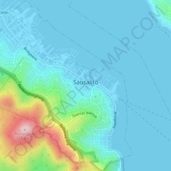
Name: Sausalito topographic map, elevation, terrain.
Location: Sausalito, Marin County, California, 94965, United States (37.84368 -122.51026 37.87314 -122.47537)
Average elevation: 55 m
Minimum elevation: -2 m
Maximum elevation: 338 m
Other topographic maps
Click on a map to view its topography, its elevation and its terrain.
Marshall
United States > California > Marin County
Marshall is an unincorporated community in Marin County, California. It is located on the northeast shore of Tomales Bay 6 mi (9.7 km) south of Tomales, at an elevation of 25 ft (7.6 m).
Average elevation: 51 m