
Thank you for supporting this site ❤️
Make a donation
Make a donation
Gear up for your next adventure:
As an Amazon Associate, this site earns from qualifying purchases at no extra cost to you.
Milburn topographic map
Click on the map to display elevation.
Thank you for supporting this site ❤️
Make a donation
Make a donation
Gear up for your next adventure:
As an Amazon Associate, this site earns from qualifying purchases at no extra cost to you.
About this map
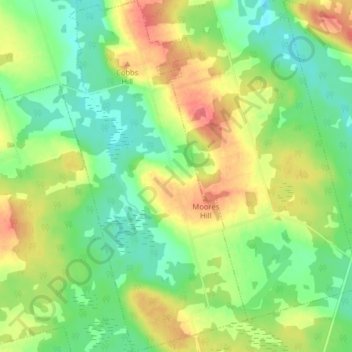
Name: Milburn topographic map, elevation, terrain.
Location: Milburn, Kings County, Prince Edward Island, Canada (46.33578 -62.66342 46.39103 -62.62053)
Average elevation: 29 m
Minimum elevation: 3 m
Maximum elevation: 63 m
Thank you for supporting this site ❤️
Make a donation
Make a donation
Gear up for your next adventure:
🐍Australian Snake Bite Kits - Specific pressure immobilization bandages for Australian venomous snakes
As an Amazon Associate, this site earns from qualifying purchases at no extra cost to you.
Other topographic maps
Click on a map to view its topography, its elevation and its terrain.
Prince Edward Island National Park
Canada > Prince Edward Island > Kings County > Greenwich
Average elevation: 2 m