
Filloi topographic map
Interactive map
Click on the map to display elevation.
About this map
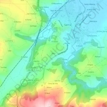
Name: Filloi topographic map, elevation, terrain.
Location: Filloi, Farbán, Sarria, Lugo, Galicia, 27619, España (42.74765 -7.44190 42.78765 -7.40190)
Average elevation: 490 m
Minimum elevation: 413 m
Maximum elevation: 660 m
Other topographic maps
Click on a map to view its topography, its elevation and its terrain.
San Fiz de Reimóndez
España > Galicia > Sarria > Sarria
San Fiz de Reimóndez, Sarria, Lugo, Galicia, España
Average elevation: 566 m