
Lakeba Island topographic map
Interactive map
Click on the map to display elevation.
About this map
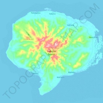
Name: Lakeba Island topographic map, elevation, terrain.
Location: Lakeba Island, Tubou, Lau, Eastern, Fiji (-18.25788 -178.83959 -18.17383 -178.73574)
Average elevation: 27 m
Minimum elevation: -1 m
Maximum elevation: 215 m
Situated at 18.20° South and 178.80° East, Lakeba has an irregular oval shape. About 9 kilometers long and 8 kilometers wide, it is circumscribed by a total shoreline of 32 kilometers. The island, which has a maximum altitude of 219 meters, has a core of andesitic volcanic rock of Miocene age, with raised coral rock around it. The limestone lies bare in places, forming karst and – particularly on the north and north-west coasts – cliffs up to 76 meters high; the overall area taken up by bare limestone is about 4% of Lakeba's total land surface. A reforestation programme has seen the planting of Lakeba's hills (formerly partially denuded by deforestation) with Caribbean pine (Pinus caribea) trees.