
Cocos Island topographic map
Interactive map
Click on the map to display elevation.
About this map
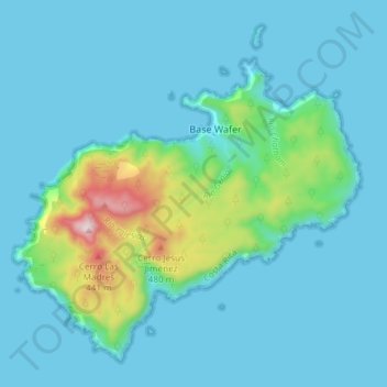
Name: Cocos Island topographic map, elevation, terrain.
Average elevation: 77 m
Minimum elevation: -2 m
Maximum elevation: 573 m
Other topographic maps
Click on a map to view its topography, its elevation and its terrain.
Playa Tambor
Costa Rica > Cantón Puntarenas > Cóbano > Tambor
Playa Tambor, Tambor, Cóbano, Cantón Puntarenas, Provincia Puntarenas, 60111, Costa Rica
Average elevation: 39 m