
Sandness topographic map
Interactive map
Click on the map to display elevation.
About this map
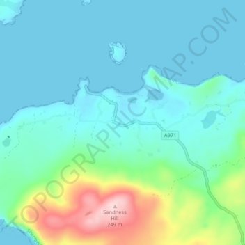
Name: Sandness topographic map, elevation, terrain.
Location: Sandness, Shetland, Scotland, ZE2 9PL, United Kingdom (60.27885 -1.67220 60.31885 -1.63220)
Average elevation: 48 m
Minimum elevation: -3 m
Maximum elevation: 247 m
Other topographic maps
Click on a map to view its topography, its elevation and its terrain.
Island
United Kingdom > Scotland > Shetland > Mid Yell
Island, Yell, Mid Yell, Shetland, Scotland, United Kingdom
Average elevation: 20 m
Lerwick
United Kingdom > Scotland > Shetland
Lerwick, Shetland, Scotland, United Kingdom
Average elevation: 34 m
Fair Isle
United Kingdom > Scotland > Shetland > Stonybreck
Fair Isle, Stonybreck, Shetland, Scotland, ZE2 9JU, United Kingdom
Average elevation: 22 m
Shetland
United Kingdom > Scotland > Shetland
Shetland, Scotland, United Kingdom
Average elevation: 11 m
Nista
United Kingdom > Scotland > Shetland
Nista, Whalsay, Shetland, Scotland, United Kingdom
Average elevation: 1 m