Geolocate

Kibisi topographic map

Click on the map to display elevation.

About this map

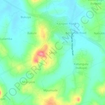
Name: Kibisi topographic map, elevation, terrain.

Location: Kibisi, Kassanda, Central Region, Uganda (0.64503 31.80994 0.68503 31.84994)

Average elevation: 1,181 m

Minimum elevation: 1,151 m

Maximum elevation: 1,257 m

Gear up for your next adventure:

🧢Wide Brim Sun Hats - Maximum coverage for the face and neck while out in the open
🍴Titanium Spork & Cutlery - Indestructible and feather-light eating utensils
🔦LED Torches - LED torches for outdoor use
Survival Blankets - Emergency thermal blankets
🔥Ferrocerium Rod Fire Starters - Reliable fire lighting in wet or windy conditions without matches

As an Amazon Associate, this site earns from qualifying purchases at no extra cost to you.