
Saalburg topographic map
Interactive map
Click on the map to display elevation.
About this map
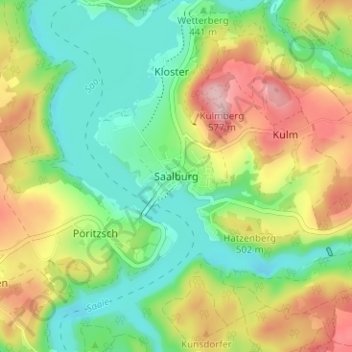
Name: Saalburg topographic map, elevation, terrain.
Average elevation: 463 m
Minimum elevation: 393 m
Maximum elevation: 570 m
Other topographic maps
Click on a map to view its topography, its elevation and its terrain.
Ranis
Deutschland > Thüringen > Saale-Orla-Kreis
Ranis, Ranis-Ziegenrück, Saale-Orla-Kreis, Thüringen, 07389, Deutschland
Average elevation: 377 m
Wurzbach
Deutschland > Thüringen > Saale-Orla-Kreis
Wurzbach, Saale-Orla-Kreis, Thüringen, 07343, Deutschland
Average elevation: 610 m