
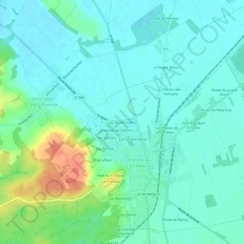
Les Quatre Vents topographic map
Interactive map
Click on the map to display elevation.
About this map
Name: Les Quatre Vents topographic map, elevation, terrain.
Average elevation: 129 m
Minimum elevation: 115 m
Maximum elevation: 171 m
Other topographic maps
Click on a map to view its topography, its elevation and its terrain.
L'Ecole Militaire
France > Grand Est > Aube > Brienne-le-Château
L'Ecole Militaire, Brienne-le-Château, Bar-sur-Aube, Aube, Grand Est, France métropolitaine, 10500, France
Average elevation: 130 m
Les Fleuriottes
France > Grand Est > Aube > Brienne-le-Château
Les Fleuriottes, Brienne-le-Château, Bar-sur-Aube, Aube, Grand Est, France métropolitaine, 10500, France
Average elevation: 132 m
La Gare
France > Grand Est > Aube > Brienne-le-Château
La Gare, Brienne-le-Château, Bar-sur-Aube, Aube, Grand Est, France métropolitaine, 10500, France
Average elevation: 128 m