
Stanwell Tops Lookout topographic map
Interactive map
Click on the map to display elevation.
About this map
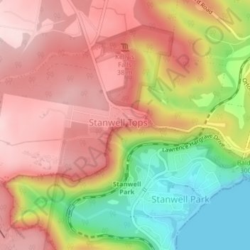
Name: Stanwell Tops Lookout topographic map, elevation, terrain.
Average elevation: 172 m
Minimum elevation: 0 m
Maximum elevation: 292 m
Other topographic maps
Click on a map to view its topography, its elevation and its terrain.
Mount Pleasant
Australia > New South Wales > Wollongong City Council
Mount Pleasant, Wollongong City Council, New South Wales, 2519, Australia
Average elevation: 140 m
Stanwell Park
Australia > New South Wales > Wollongong City Council
Stanwell Park, Wollongong City Council, New South Wales, 2508, Australia
Average elevation: 96 m