
Douglas Pass topographic map
Interactive map
Click on the map to display elevation.
About this map
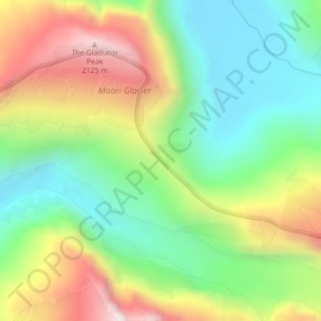
Name: Douglas Pass topographic map, elevation, terrain.
Location: Douglas Pass, Westland District, West Coast, New Zealand (-43.72095 169.97029 -43.72085 169.97039)
Average elevation: 1,603 m
Minimum elevation: 1,241 m
Maximum elevation: 2,160 m
Other topographic maps
Click on a map to view its topography, its elevation and its terrain.
Lake Windermere
New Zealand > West Coast > Westland District
Lake Windermere, Westland District, West Coast, New Zealand
Average elevation: 4 m
Katau Knob
New Zealand > West Coast > Westland District
Katau Knob, Westland District, West Coast, New Zealand
Average elevation: 826 m
Snowden
New Zealand > West Coast > Westland District
Snowden, Westland District, West Coast, New Zealand
Average elevation: 1,049 m
Mt Wilson
New Zealand > West Coast > Westland District
Mt Wilson, Westland District, West Coast, New Zealand
Average elevation: 1,126 m
Ōkārito
New Zealand > West Coast > Westland District
Ōkārito, Westland District, West Coast, New Zealand
Average elevation: 25 m
Whataroa River
New Zealand > West Coast > Westland District
Whataroa River, Westland District, West Coast, New Zealand
Average elevation: 626 m