
River Kennet topographic map
Interactive map
Click on the map to display elevation.
About this map
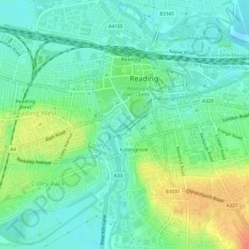
Name: River Kennet topographic map, elevation, terrain.
Average elevation: 47 m
Minimum elevation: 32 m
Maximum elevation: 78 m
Other topographic maps
Click on a map to view its topography, its elevation and its terrain.
Old Mills
United Kingdom > England > Bath and North East Somerset > Paulton
Old Mills, Paulton, Bath and North East Somerset, West of England, England, BS39 7SR, United Kingdom
Average elevation: 126 m
Clandown
United Kingdom > England > Bath and North East Somerset > Radstock
Clandown, Radstock, Bath and North East Somerset, West of England, England, BA3 3DW, United Kingdom
Average elevation: 118 m
Peasedown St. John
United Kingdom > England > Bath and North East Somerset
Peasedown St. John, Bath and North East Somerset, West of England, England, United Kingdom
Average elevation: 125 m
Batheaston
United Kingdom > England > Bath and North East Somerset > Batheaston
Batheaston, Bath and North East Somerset, West of England, England, United Kingdom
Average elevation: 114 m
Bath
United Kingdom > England > Bath and North East Somerset
Bath, Bath and North East Somerset, West of England, England, United Kingdom
Average elevation: 100 m
Chew Magna
United Kingdom > England > Bath and North East Somerset > Chew Magna
Chew Magna, Bath and North East Somerset, West of England, England, United Kingdom
Average elevation: 90 m
Monkton Combe
United Kingdom > England > Bath and North East Somerset
Monkton Combe, Bath and North East Somerset, West of England, England, United Kingdom
Average elevation: 102 m