
Astoria topographic map
Interactive map
Click on the map to display elevation.
About this map
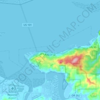
Name: Astoria topographic map, elevation, terrain.
Location: Astoria, Clatsop County, Oregon, 97103, United States (46.16995 -123.87418 46.21494 -123.73924)
Average elevation: 15 m
Minimum elevation: -4 m
Maximum elevation: 204 m
Other topographic maps
Click on a map to view its topography, its elevation and its terrain.
Seaside
United States > Oregon > Clatsop County
Seaside, Clatsop County, Oregon, United States
Average elevation: 84 m
Flat Iron Mountain
United States > Oregon > Clatsop County
Flat Iron Mountain, Clatsop County, Oregon, United States
Average elevation: 547 m
Westport
United States > Oregon > Clatsop County
Westport, Clatsop County, Oregon, United States
Average elevation: 61 m
Svensen
United States > Oregon > Clatsop County
Svensen, Clatsop County, Oregon, United States
Average elevation: 21 m
Knappa
United States > Oregon > Clatsop County
Knappa, Clatsop County, Oregon, United States
Average elevation: 63 m
Astoria
United States > Oregon > Clatsop County > Astoria
Astoria, Clatsop County, Oregon, 97103, United States
Average elevation: 17 m
Fishhawk Lake
United States > Oregon > Clatsop County
Fishhawk Lake, Clatsop County, Oregon, United States
Average elevation: 257 m
Gearhart
United States > Oregon > Clatsop County
Gearhart, Clatsop County, Oregon, United States
Average elevation: 17 m
Cannon Beach
United States > Oregon > Clatsop County
Cannon Beach, Clatsop County, Oregon, United States
Average elevation: 42 m
Warrenton
United States > Oregon > Clatsop County
Warrenton, Clatsop County, Oregon, United States
Average elevation: 4 m
Arch Cape
United States > Oregon > Clatsop County
Arch Cape, Clatsop County, Oregon, 97102, United States
Average elevation: 73 m
Sunset Beach
United States > Oregon > Clatsop County
Sunset Beach, Clatsop County, Oregon, United States
Average elevation: 11 m
Humbug Mountain
United States > Oregon > Clatsop County
Humbug Mountain, Clatsop County, Oregon, United States
Average elevation: 463 m
Fort Stevens
United States > Oregon > Clatsop County > Hammond > Fort Stevens
Fort Stevens, Hammond, Clatsop County, Oregon, 97121, United States
Average elevation: 3 m
Ecola State Park
United States > Oregon > Clatsop County > Seaside
Ecola State Park, Seaside, Clatsop County, Oregon, United States
Average elevation: 64 m
Mishawaka
United States > Oregon > Clatsop County > Elderberry
Mishawaka, Elderberry, Clatsop County, Oregon, United States
Average elevation: 204 m