
Eccica topographic map
Interactive map
Click on the map to display elevation.
About this map
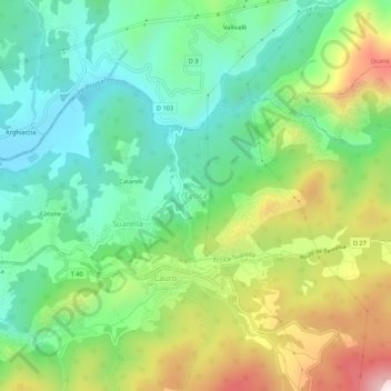
Name: Eccica topographic map, elevation, terrain.
Average elevation: 304 m
Minimum elevation: 68 m
Maximum elevation: 747 m
Other topographic maps
Click on a map to view its topography, its elevation and its terrain.
Catarelli
France > Corse > Corse-du-Sud > Eccica-Suarella > Suarella
Catarelli, Suarella, Eccica-Suarella, Ajaccio, Corse-du-Sud, Corse, France métropolitaine, 20117, France
Average elevation: 254 m
Suarella
France > Corse > Corse-du-Sud > Eccica-Suarella
Suarella, Eccica-Suarella, Ajaccio, Corse-du-Sud, Corse, France métropolitaine, 20117, France
Average elevation: 277 m