
Make a donation
Gear up for your next adventure:
As an Amazon Associate, this site earns from qualifying purchases at no extra cost to you.
Gratkorn topographic map
Click on the map to display elevation.
Make a donation
Gear up for your next adventure:
As an Amazon Associate, this site earns from qualifying purchases at no extra cost to you.
About this map
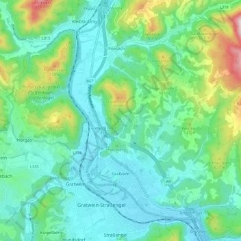
Name: Gratkorn topographic map, elevation, terrain.
Location: Gratkorn, Bezirk Graz-Umgebung, Styria, 8101, Austria (47.11219 15.31686 47.18551 15.41113)
Average elevation: 489 m
Minimum elevation: 367 m
Maximum elevation: 896 m
Make a donation
Gear up for your next adventure:
As an Amazon Associate, this site earns from qualifying purchases at no extra cost to you.
Other topographic maps
Click on a map to view its topography, its elevation and its terrain.
Sankt Marein bei Graz
Austria > Styria > Bezirk Graz-Umgebung > St. Marein bei Graz
Average elevation: 395 m
Make a donation
Gear up for your next adventure:
As an Amazon Associate, this site earns from qualifying purchases at no extra cost to you.