
Thank you for supporting this site ❤️
Make a donation
Make a donation
Gear up for your next adventure:
As an Amazon Associate, this site earns from qualifying purchases at no extra cost to you.
Rifle topographic map
Click on the map to display elevation.
Thank you for supporting this site ❤️
Make a donation
Make a donation
Gear up for your next adventure:
As an Amazon Associate, this site earns from qualifying purchases at no extra cost to you.
About this map
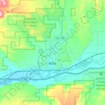
Name: Rifle topographic map, elevation, terrain.
Location: Rifle, Garfield County, Colorado, United States (39.51492 -107.84737 39.57478 -107.72263)
Average elevation: 1,731 m
Minimum elevation: 1,598 m
Maximum elevation: 2,149 m
Thank you for supporting this site ❤️
Make a donation
Make a donation
Gear up for your next adventure:
🧭Military Style Lensatic Compass - Durable sighting compasses for advanced land navigation and surveying
As an Amazon Associate, this site earns from qualifying purchases at no extra cost to you.
Other topographic maps
Click on a map to view its topography, its elevation and its terrain.
Thank you for supporting this site ❤️
Make a donation
Make a donation
Gear up for your next adventure:
As an Amazon Associate, this site earns from qualifying purchases at no extra cost to you.