
Make a donation
Gear up for your next adventure:
As an Amazon Associate, this site earns from qualifying purchases at no extra cost to you.
Highwood topographic map
Click on the map to display elevation.
Make a donation
Gear up for your next adventure:
As an Amazon Associate, this site earns from qualifying purchases at no extra cost to you.
Highwood
Highwood is located in southeastern Lake County at 42°12′19″N 87°48′44″W / 42.205357°N 87.812345°W / 42.205357; -87.812345, on a ridge 100 feet (30 m) above the elevation of Lake Michigan.
Make a donation
Gear up for your next adventure:
As an Amazon Associate, this site earns from qualifying purchases at no extra cost to you.
About this map
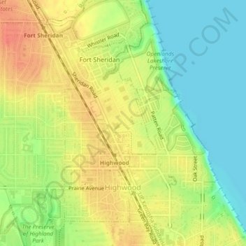
Name: Highwood topographic map, elevation, terrain.
Location: Highwood, Lake County, Illinois, 60040, United States (42.19608 -87.82154 42.21779 -87.80438)
Average elevation: 198 m
Minimum elevation: 174 m
Maximum elevation: 220 m
Make a donation
Gear up for your next adventure:
As an Amazon Associate, this site earns from qualifying purchases at no extra cost to you.
Other topographic maps
Click on a map to view its topography, its elevation and its terrain.
Make a donation
Gear up for your next adventure:
As an Amazon Associate, this site earns from qualifying purchases at no extra cost to you.
Make a donation
Gear up for your next adventure:
As an Amazon Associate, this site earns from qualifying purchases at no extra cost to you.
Bishops Ridge
United States > Illinois > Lake County > Kildeer > Bishops Ridge
Average elevation: 253 m
Make a donation
Gear up for your next adventure:
As an Amazon Associate, this site earns from qualifying purchases at no extra cost to you.
Lake Naomi
United States > Illinois > Lake County > Hawthorn Woods > White Birch Lakes
Average elevation: 261 m