
Worcester, England topographic map
Interactive map
Click on the map to display elevation.
About this map
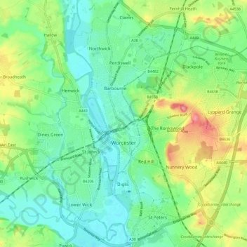
Name: Worcester, England topographic map, elevation, terrain.
Location: Worcester, England, Worcestershire, England, United Kingdom (52.16164 -2.26321 52.23139 -2.15730)
Average elevation: 38 m
Minimum elevation: 10 m
Maximum elevation: 96 m
Other topographic maps
Click on a map to view its topography, its elevation and its terrain.
South Littleton
United Kingdom > England > Worcestershire > Wychavon
South Littleton, Wychavon, Worcestershire, England, United Kingdom
Average elevation: 38 m
Redditch
United Kingdom > England > Worcestershire > Redditch
Redditch, Worcestershire, England, B97 4ET, United Kingdom
Average elevation: 115 m
Evesham
United Kingdom > England > Worcestershire > Wychavon
Evesham, Wychavon, Worcestershire, England, United Kingdom
Average elevation: 38 m
Worcester
United Kingdom > England > Worcestershire > Worcester
Worcester, Worcester, England, Worcestershire, West Midlands, England, WR1 2ZB, United Kingdom
Average elevation: 72 m
Kemerton
United Kingdom > England > Worcestershire > Wychavon
Kemerton, Wychavon, Worcestershire, England, United Kingdom
Average elevation: 85 m
Wythall CP
United Kingdom > England > Worcestershire > Bromsgrove > Wythall CP
Wythall CP, Bromsgrove, Worcestershire, West Midlands, England, United Kingdom
Average elevation: 155 m
Redditch
United Kingdom > England > Worcestershire > Redditch
Redditch, Worcestershire, West Midlands, England, United Kingdom
Average elevation: 99 m
Wychavon
United Kingdom > England > Worcestershire > Wychavon
Wychavon, Worcestershire, England, United Kingdom
Average elevation: 68 m
Malvern
United Kingdom > England > Worcestershire > Malvern Hills District
Malvern, Malvern Hills District, Worcestershire, England, WR14 2HX, United Kingdom
Average elevation: 95 m
Hill End
United Kingdom > England > Worcestershire > Wychavon
Hill End, Wychavon, Worcestershire, England, WR9 8LJ, United Kingdom
Average elevation: 47 m