
Make a donation
Gear up for your next adventure:
As an Amazon Associate, this site earns from qualifying purchases at no extra cost to you.
Joinville topographic map
Click on the map to display elevation.
Make a donation
Gear up for your next adventure:
As an Amazon Associate, this site earns from qualifying purchases at no extra cost to you.
Joinville
Joinville has a humid subtropical climate (Cfa in the Köppen climate classification data). In some rare cases, Joinville gets hit by South Atlantic cyclones, the most notable being Cyclone Catarina in 2004. Although Joinville lies outside the tropic zone, because of its low altitude and proximity to the Atlantic Ocean, it sees relatively little temperature variation throughout the year, with every month seeing average highs in the 20s C.
Make a donation
Gear up for your next adventure:
As an Amazon Associate, this site earns from qualifying purchases at no extra cost to you.
About this map
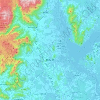
Name: Joinville topographic map, elevation, terrain.
Average elevation: 162 m
Minimum elevation: -2 m
Maximum elevation: 1,355 m
Make a donation
Gear up for your next adventure:
As an Amazon Associate, this site earns from qualifying purchases at no extra cost to you.