
Kantabrien topographic map
Interactive map
Click on the map to display elevation.
About this map
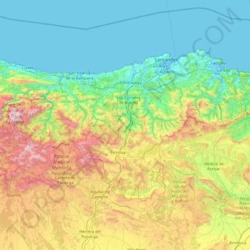
Name: Kantabrien topographic map, elevation, terrain.
Location: Kantabrien, Spanien (42.75805 -4.85174 43.51362 -3.14965)
Average elevation: 609 m
Minimum elevation: -3 m
Maximum elevation: 2,603 m
Other topographic maps
Click on a map to view its topography, its elevation and its terrain.
La Granada
Spanien > Kantabrien > San Vicente de la Barquera
La Granada, San Vicente de la Barquera, Costa Occidental, Cantabria, Kantabrien, 39549, Spanien
Average elevation: 235 m