
Serbie centrale topographic map
Interactive map
Click on the map to display elevation.
About this map
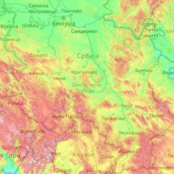
Name: Serbie centrale topographic map, elevation, terrain.
Location: Serbie centrale, Serbie (42.23145 19.10259 45.09690 23.00631)
Average elevation: 583 m
Minimum elevation: 1 m
Maximum elevation: 2,651 m
Other topographic maps
Click on a map to view its topography, its elevation and its terrain.
Novi Pazar
Serbie > Serbie centrale > Рашки управни округ
Novi Pazar, Рашки управни округ, Serbie centrale, Serbie
Average elevation: 889 m
Урсуле
Serbie > Serbie centrale > Општина Сјеница
Урсуле, Општина Сјеница, Златиборски управни округ, Serbie centrale, Serbie
Average elevation: 1,121 m
Мађаре
Serbie > Serbie centrale > Мађаре
Мађаре, Пчињски управни округ, Serbie centrale, Serbie
Average elevation: 756 m
Грубетиће
Serbie > Serbie centrale > Отеш
Грубетиће, Отеш, Град Нови Пазар, Рашки управни округ, Serbie centrale, Serbie
Average elevation: 983 m
Радиофар
Serbie > Serbie centrale > Градска општина Сурчин
Радиофар, Градска општина Сурчин, Ville de Belgrade, Serbie centrale, 11180, Serbie
Average elevation: 95 m
Мађаре
Serbie > Serbie centrale > Општина Прешево
Мађаре, Општина Прешево, Пчињски управни округ, Serbie centrale, Serbie
Average elevation: 752 m
Манић
Serbie > Serbie centrale > Манић
Манић, Ville de Belgrade, Serbie centrale, Serbie
Average elevation: 177 m