
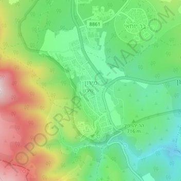
Meron topographic map
Interactive map
Click on the map to display elevation.
About this map
Name: Meron topographic map, elevation, terrain.
Average elevation: 735 m
Minimum elevation: 571 m
Maximum elevation: 1,004 m
Meron is noted for its mountainous terrain and valleys. Among the local attractions are the Meron Vineyards. Meron is conducive to growing grapes for wine as a result of its 600-meter altitude and chalky soil. The vineyard was first planted in 2000 and is part of the Galil Mountain Winery, headquartered in nearby Kibbutz Yiron.
Other topographic maps
Click on a map to view its topography, its elevation and its terrain.
Livnim
Israel > North District > Merom HaGalil Regional Council
Livnim, Merom HaGalil Regional Council, Safed Subdistrict, North District, Israel
Average elevation: -83 m
Amirim
Israel > North District > Merom HaGalil Regional Council
Amirim, Merom HaGalil Regional Council, Safed Subdistrict, North District, Israel
Average elevation: 512 m
Avivim
Israel > North District > Merom HaGalil Regional Council > Avivim
Avivim, Merom HaGalil Regional Council, Safed Subdistrict, North District, Israel
Average elevation: 704 m
Mount Meron
Israel > North District > Merom HaGalil Regional Council
Mount Meron, Merom HaGalil Regional Council, Safed Subdistrict, North District, Israel
Average elevation: 943 m