
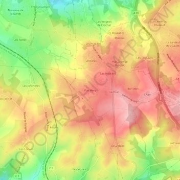
Puy Méry topographic map
Interactive map
Click on the map to display elevation.
About this map
Name: Puy Méry topographic map, elevation, terrain.
Average elevation: 327 m
Minimum elevation: 239 m
Maximum elevation: 388 m
Other topographic maps
Click on a map to view its topography, its elevation and its terrain.
Les Pradilles
France > Nouvelle-Aquitaine > Haute-Vienne > Le Vigen
Les Pradilles, Le Vigen, Limoges, Haute-Vienne, Nouvelle-Aquitaine, France métropolitaine, 87110, France
Average elevation: 329 m
Puy Jalard
France > Nouvelle-Aquitaine > Haute-Vienne > Le Vigen
Puy Jalard, Le Vigen, Limoges, Haute-Vienne, Nouvelle-Aquitaine, France métropolitaine, 87110, France
Average elevation: 299 m