Geolocate

Subaúma topographic map

Click on the map to display elevation.

About this map
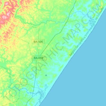
Name: Subaúma topographic map, elevation, terrain.

Location: Subaúma, Entre Rios, Região Geográfica Imediata de Alagoinhas, Região Geográfica Intermediária de Salvador, Bahia, Região Nordeste, Brasil (-12.40769 -38.02213 -12.17005 -37.76107)

Average elevation: 34 m

Minimum elevation: -1 m

Maximum elevation: 190 m

Other topographic maps

Click on a map to view its topography, its elevation and its terrain.

Sauípe de Dentro

Brasil > Bahia > Entre Rios

Average elevation: 26 m

Monte Alegre

Brasil > Bahia > Entre Rios

Average elevation: 121 m

Lagoa Redonda

Brasil > Bahia > Entre Rios > Lagoa Redonda

Average elevation: 101 m

Massarandupió

Brasil > Bahia > Entre Rios

Average elevation: 23 m

Gear up for your next adventure:

🛌Compact Down Sleeping Bags - Warmth without the bulk, ideal for backcountry camping
🧊Insulated Cooler Bags - Keep food fresh for day trips to remote geographic sites
🐍Snake Gaiters - Protection against snake bites
🥾Heavy Duty Hiking Boots - Ankle-supporting boots for carrying heavy packs on steep contours
🥾Trail Running Shoes - Shoes for trail running

As an Amazon Associate, this site earns from qualifying purchases at no extra cost to you.