
Folampelle topographic map
Interactive map
Click on the map to display elevation.
About this map
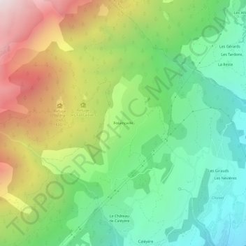
Name: Folampelle topographic map, elevation, terrain.
Average elevation: 1,499 m
Minimum elevation: 884 m
Maximum elevation: 2,499 m
Other topographic maps
Click on a map to view its topography, its elevation and its terrain.
Le Petit Puy
France > Provence-Alpes-Côte d'Azur > Hautes-Alpes > Embrun
Le Petit Puy, Embrun, Gap, Hautes-Alpes, Provence-Alpes-Côte d'Azur, France métropolitaine, 05200, France
Average elevation: 1,143 m
Mont Guillaume
France > Provence-Alpes-Côte d'Azur > Hautes-Alpes > Embrun
Mont Guillaume, Embrun, Gap, Hautes-Alpes, Provence-Alpes-Côte d'Azur, France métropolitaine, 05200, France
Average elevation: 2,097 m
Les Nevières
France > Provence-Alpes-Côte d'Azur > Hautes-Alpes > Embrun
Les Nevières, Embrun, Gap, Hautes-Alpes, Provence-Alpes-Côte d'Azur, France métropolitaine, 05200, France
Average elevation: 1,054 m