
Thank you for supporting this site ❤️
Make a donation
Make a donation
Gear up for your next adventure:
As an Amazon Associate, this site earns from qualifying purchases at no extra cost to you.
Bokin topographic map
Click on the map to display elevation.
Thank you for supporting this site ❤️
Make a donation
Make a donation
Gear up for your next adventure:
As an Amazon Associate, this site earns from qualifying purchases at no extra cost to you.
About this map
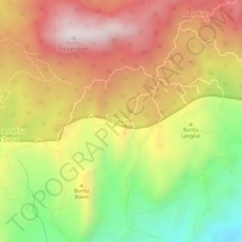
Name: Bokin topographic map, elevation, terrain.
Location: Bokin, Toraja Utara, South Sulawesi, Sulawesi, Indonesia (-3.05135 119.99010 -3.01135 120.03010)
Average elevation: 1,038 m
Minimum elevation: 557 m
Maximum elevation: 1,462 m
Thank you for supporting this site ❤️
Make a donation
Make a donation
Gear up for your next adventure:
As an Amazon Associate, this site earns from qualifying purchases at no extra cost to you.