
Vallegrande topographic map
Interactive map
Click on the map to display elevation.
About this map
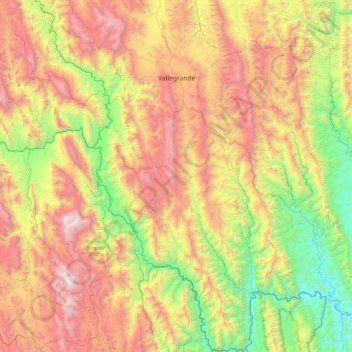
Name: Vallegrande topographic map, elevation, terrain.
Location: Vallegrande, Santa Cruz, Bolivia (-19.18451 -64.30318 -18.29254 -63.53131)
Average elevation: 1,694 m
Minimum elevation: 505 m
Maximum elevation: 3,430 m
Other topographic maps
Click on a map to view its topography, its elevation and its terrain.
Lagunillas
Bolivia > Santa Cruz > Vallegrande > Municipio Trigal
Lagunillas, Municipio Trigal, Vallegrande, Santa Cruz, Bolivia
Average elevation: 1,596 m
El Trigal
Bolivia > Santa Cruz > Vallegrande > El Trigal
El Trigal, Vallegrande, Santa Cruz, Bolivia
Average elevation: 1,668 m