
Lois Hole Centennial Provincial Park topographic map
Interactive map
Click on the map to display elevation.
About this map
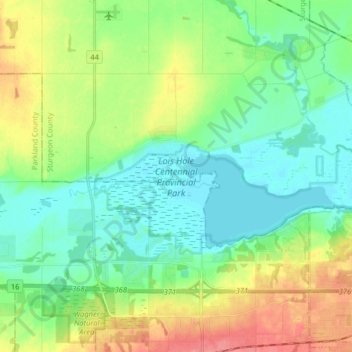
Name: Lois Hole Centennial Provincial Park topographic map, elevation, terrain.
Average elevation: 671 m
Minimum elevation: 649 m
Maximum elevation: 715 m
The park is situated on the shores of Big Lake, on the lower course of the Sturgeon River, at an elevation of 660 m (2,170 ft). It is maintained by Alberta Tourism, Parks and Recreation and was established on April 19, 2005, on lands designated in 1999 as Big Lake Natural Area (part of the Special Places program). It is the latest provincial park to be established in the province, and Alberta's 69th provincial park.