
Binnensee topographic map
Interactive map
Click on the map to display elevation.
About this map
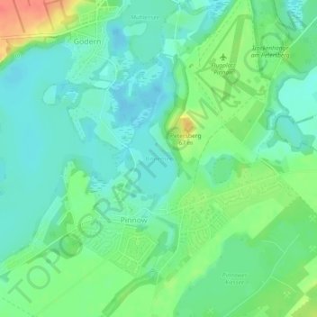
Name: Binnensee topographic map, elevation, terrain.
Average elevation: 37 m
Minimum elevation: 21 m
Maximum elevation: 72 m
Other topographic maps
Click on a map to view its topography, its elevation and its terrain.
Godern
Deutschland > Mecklenburg-Vorpommern > Pinnow
Godern, Pinnow, Crivitz, Ludwigslust-Parchim, Mecklenburg-Vorpommern, Deutschland
Average elevation: 48 m