Geolocate

Hell topographic map

Click on the map to display elevation.

About this map

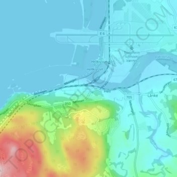
Name: Hell topographic map, elevation, terrain.

Location: Hell, Stjørdal, Trøndelag, 7517, Norway (63.42492 10.89272 63.46492 10.93272)

Average elevation: 51 m

Minimum elevation: -3 m

Maximum elevation: 271 m

Other topographic maps

Click on a map to view its topography, its elevation and its terrain.

Inderøy

Norway > Trøndelag

Average elevation: 155 m

Selbu

Norway > Trøndelag

Average elevation: 549 m

Stjørdal

Norway > Trøndelag

Average elevation: 314 m

Verdal

Norway > Trøndelag

Average elevation: 402 m

Austra

Norway > Trøndelag

Average elevation: 97 m

Herøya

Norway > Trøndelag

Average elevation: 2 m

Gear up for your next adventure:

🌬️Windbreaker Jackets - Wind protection jackets
🧢Wide Brim Sun Hats - Maximum coverage for the face and neck while out in the open
📡Portable Emergency Radios - Stay informed about weather warnings and bushfire alerts
🕯️Emergency Whistles - Safety whistles for hiking
🧊Insulated Stainless Steel Flasks - Keep water cold for 24 hours in the heat or coffee hot in the cold

As an Amazon Associate, this site earns from qualifying purchases at no extra cost to you.