
Make a donation
Gear up for your next adventure:
As an Amazon Associate, this site earns from qualifying purchases at no extra cost to you.
Reichenschwand topographic map
Click on the map to display elevation.
Make a donation
Gear up for your next adventure:
As an Amazon Associate, this site earns from qualifying purchases at no extra cost to you.
Reichenschwand
Im Jahr 2022 erzielte Reichenschwand Einnahmen aus der Gewerbesteuer in Höhe von 1,55 Millionen Euro. Mit einem Gewerbesteuerhebesatz von 310 % zählt die Gemeinde zu den steuerlich attraktivsten Standorten Deutschlands. Reichenschwand ist etwa steuerlich deutlich günstiger als Nürnberg (Gewerbesteuerhebesatz 467 %).
Make a donation
Gear up for your next adventure:
As an Amazon Associate, this site earns from qualifying purchases at no extra cost to you.
About this map
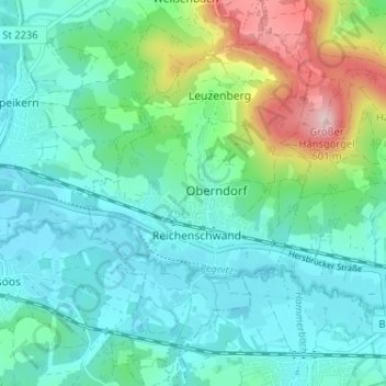
Name: Reichenschwand topographic map, elevation, terrain.
Average elevation: 383 m
Minimum elevation: 321 m
Maximum elevation: 592 m
Make a donation
Gear up for your next adventure:
As an Amazon Associate, this site earns from qualifying purchases at no extra cost to you.
Other topographic maps
Click on a map to view its topography, its elevation and its terrain.
Ludersheim
Deutschland > Bayern > Landkreis Nürnberger Land > Altdorf bei Nürnberg
Average elevation: 428 m
Rasch
Deutschland > Bayern > Landkreis Nürnberger Land > Altdorf bei Nürnberg
Average elevation: 425 m
Hohenstein
Deutschland > Bayern > Landkreis Nürnberger Land
Hohenstein ist ein Gemeindeteil der Gemeinde Kirchensittenbach im Landkreis Nürnberger Land (Mittelfranken, Bayern). Der Ort liegt in der Hersbrucker Alb auf dem Hohensteiner Berg und hat etwa 150 Einwohner. Im westlichen Bereich des Ortsgebietes befindet sich die auf 624 Meter Höhe gelegene Burg Hohenstein…
Average elevation: 513 m
Make a donation
Gear up for your next adventure:
As an Amazon Associate, this site earns from qualifying purchases at no extra cost to you.
Simonshofen
Deutschland > Bayern > Landkreis Nürnberger Land > Lauf an der Pegnitz
Das Dorf befindet sich etwa vier Kilometer nördlich des Ortszentrum von Lauf und liegt auf einer Höhe von 374 m ü. NHN.
Average elevation: 378 m
Kirchröttenbach
Deutschland > Bayern > Landkreis Nürnberger Land > Schnaittach
Average elevation: 378 m
Make a donation
Gear up for your next adventure:
As an Amazon Associate, this site earns from qualifying purchases at no extra cost to you.
Enzenreuth
Deutschland > Bayern > Landkreis Nürnberger Land > Schnaittach > Rabenshof
Average elevation: 451 m
Make a donation
Gear up for your next adventure:
As an Amazon Associate, this site earns from qualifying purchases at no extra cost to you.
Kolbenberg
Deutschland > Bayern > Landkreis Nürnberger Land > Neuhaus a.d.Pegnitz
Average elevation: 473 m
Make a donation
Gear up for your next adventure:
As an Amazon Associate, this site earns from qualifying purchases at no extra cost to you.
Rabenshof
Deutschland > Bayern > Landkreis Nürnberger Land > Schnaittach
Das in der Hersbrucker Alb gelegene Dorf befindet sich zweieinhalb Kilometer östlich des Ortszentrums von Schnaittach und liegt auf einer Höhe von 461 m ü. NHN.
Average elevation: 462 m
Make a donation
Gear up for your next adventure:
As an Amazon Associate, this site earns from qualifying purchases at no extra cost to you.
Pühlheim
Deutschland > Bayern > Landkreis Nürnberger Land > Altdorf bei Nürnberg
Average elevation: 493 m
Hagenhausen
Deutschland > Bayern > Landkreis Nürnberger Land > Altdorf bei Nürnberg
Average elevation: 435 m
Oberrieden
Deutschland > Bayern > Landkreis Nürnberger Land > Altdorf bei Nürnberg
Average elevation: 509 m
Make a donation
Gear up for your next adventure:
As an Amazon Associate, this site earns from qualifying purchases at no extra cost to you.
Nürnberg-Blick
Deutschland > Bayern > Landkreis Nürnberger Land > Diepersdorf
Average elevation: 431 m
Speckschlag
Deutschland > Bayern > Landkreis Nürnberger Land > Röthenbach an der Pegnitz
Average elevation: 331 m
Make a donation
Gear up for your next adventure:
As an Amazon Associate, this site earns from qualifying purchases at no extra cost to you.
Make a donation
Gear up for your next adventure:
As an Amazon Associate, this site earns from qualifying purchases at no extra cost to you.
Sittenbach
Deutschland > Bayern > Landkreis Nürnberger Land > Hersbruck > Weiher
Average elevation: 416 m
Make a donation
Gear up for your next adventure:
As an Amazon Associate, this site earns from qualifying purchases at no extra cost to you.
Speikern
Deutschland > Bayern > Landkreis Nürnberger Land
Eichig | Kersbach | Neunkirchen am Sand | Rollhofen | Speikern | Weißenbach | Wolfshöhe
Average elevation: 354 m
Make a donation
Gear up for your next adventure:
As an Amazon Associate, this site earns from qualifying purchases at no extra cost to you.
Egelsee
Deutschland > Bayern > Landkreis Nürnberger Land > Lauf an der Pegnitz > Dehnberg > Egelsee
Average elevation: 369 m
Make a donation
Gear up for your next adventure:
As an Amazon Associate, this site earns from qualifying purchases at no extra cost to you.
Make a donation
Gear up for your next adventure:
As an Amazon Associate, this site earns from qualifying purchases at no extra cost to you.