
Bucknall topographic map
Interactive map
Click on the map to display elevation.
About this map
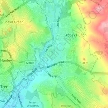
Name: Bucknall topographic map, elevation, terrain.
Average elevation: 160 m
Minimum elevation: 112 m
Maximum elevation: 251 m
Other topographic maps
Click on a map to view its topography, its elevation and its terrain.
Biddulph Valley Line
United Kingdom > England > Stoke-on-Trent > Hanley > Eaton Park
Biddulph Valley Line, Trentmill Road, Eaton Park, Hanley, Stoke-on-Trent, West Midlands, England, ST2 9NF, United Kingdom
Average elevation: 138 m
Milton
United Kingdom > England > Stoke-on-Trent > Hanley
Milton, Baddeley Green, Hanley, Stoke-on-Trent, West Midlands, England, ST2 7DP, United Kingdom
Average elevation: 158 m