
Santa Catarina topographic map
Interactive map
Click on the map to display elevation.
About this map
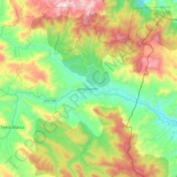
Name: Santa Catarina topographic map, elevation, terrain.
Location: Santa Catarina, Guanajuato, México (21.04672 -100.15378 21.23609 -99.99642)
Average elevation: 1,942 m
Minimum elevation: 1,458 m
Maximum elevation: 2,701 m
Other topographic maps
Click on a map to view its topography, its elevation and its terrain.
Bosque Españita
México > Guanajuato > Irapuato > Irapuato
Bosque Españita, Loma Linda, Irapuato, Guanajuato, 36613, México
Average elevation: 1,779 m
San Miguel de Allende
México > Guanajuato > San Miguel de Allende > San Miguel de Allende
San Miguel de Allende, Guanajuato, México
Average elevation: 1,964 m
Pueblo Nuevo
México > Guanajuato > Pueblo Nuevo
Pueblo Nuevo, Guanajuato, México
Average elevation: 1,721 m