
Álvaro Obregón topographic map
Interactive map
Click on the map to display elevation.
About this map
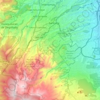
Name: Álvaro Obregón topographic map, elevation, terrain.
Location: Álvaro Obregón, Mexico City, Mexico (19.23260 -99.32435 19.40374 -99.17171)
Average elevation: 2,459 m
Minimum elevation: 2,231 m
Maximum elevation: 3,535 m
Álvaro Obregón (Spanish pronunciation: [ˈalvaɾo oβɾeˈɣon]) is a borough (demarcación territorial) in the Mexico City.[3] It contains a large portion of the south-west part of Mexico City. It had a 2010 census population of 727,034 inhabitants and lies at an elevation of 2,319 m. above sea level.
Other topographic maps
Click on a map to view its topography, its elevation and its terrain.
Alameda Central
Alameda Central, Cuauhtémoc, Mexico City, Mexico
Average elevation: 2,235 m
San Miguel Ajusco
San Miguel Ajusco, Mexico City, 14700, Mexico
Average elevation: 2,939 m