
Make a donation
Gear up for your next adventure:
As an Amazon Associate, this site earns from qualifying purchases at no extra cost to you.
Waukee topographic map
Click on the map to display elevation.
Make a donation
Gear up for your next adventure:
As an Amazon Associate, this site earns from qualifying purchases at no extra cost to you.
Waukee
Waukee, located in Walnut Township of Dallas County, Iowa, is situated on a gently rolling landscape at an average elevation of about 1,030 feet (314 meters). The topography of the area is characterized by mild elevation changes, with slight hills and valleys that form part of the broader rolling plains of the region. The terrain is shaped by various small creeks, including Little Walnut Creek, which runs through the township, adding some relief to the otherwise flat landscape. This provides a mix of open farmland and wooded areas, typical of central Iowa's midwestern terrain.
Make a donation
Gear up for your next adventure:
As an Amazon Associate, this site earns from qualifying purchases at no extra cost to you.
About this map
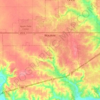
Name: Waukee topographic map, elevation, terrain.
Average elevation: 298 m
Minimum elevation: 246 m
Maximum elevation: 329 m
Make a donation
Gear up for your next adventure:
As an Amazon Associate, this site earns from qualifying purchases at no extra cost to you.