
Lulua topographic map
Interactive map
Click on the map to display elevation.
About this map
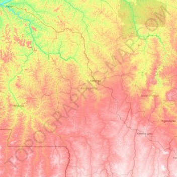
Name: Lulua topographic map, elevation, terrain.
Location: Lulua, Central Kasai, Democratic Republic of the Congo (-7.89220 21.40687 -4.20187 23.76403)
Average elevation: 656 m
Minimum elevation: 349 m
Maximum elevation: 1,053 m
Other topographic maps
Click on a map to view its topography, its elevation and its terrain.
Kananga
Democratic Republic of the Congo > Central Kasai > Kananga
Kananga, Lulua, Central Kasai, Democratic Republic of the Congo
Average elevation: 602 m