
Bockstein topographic map
Interactive map
Click on the map to display elevation.
About this map
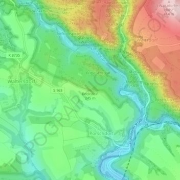
Name: Bockstein topographic map, elevation, terrain.
Average elevation: 228 m
Minimum elevation: 126 m
Maximum elevation: 411 m
Other topographic maps
Click on a map to view its topography, its elevation and its terrain.
Großer Winterberg
Deutschland > Sachsen > Bad Schandau
Großer Winterberg, Bad Schandau, Sächsische Schweiz-Osterzgebirge, Sachsen, Deutschland
Average elevation: 390 m
Neuer Wildenstein
Deutschland > Sachsen > Bad Schandau
Neuer Wildenstein, Bad Schandau, Sächsische Schweiz-Osterzgebirge, Sachsen, 01855, Deutschland
Average elevation: 267 m