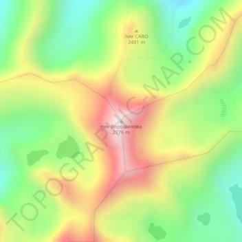
пик Ворошилова topographic map
Interactive map
Click on the map to display elevation.
About this map
Name: пик Ворошилова topographic map, elevation, terrain.
Average elevation: 2,343 m
Minimum elevation: 2,010 m
Maximum elevation: 2,758 m

Click on the map to display elevation.
Name: пик Ворошилова topographic map, elevation, terrain.
Average elevation: 2,343 m
Minimum elevation: 2,010 m
Maximum elevation: 2,758 m