
Make a donation
Gear up for your next adventure:
As an Amazon Associate, this site earns from qualifying purchases at no extra cost to you.
Quezon topographic map
Click on the map to display elevation.
Make a donation
Gear up for your next adventure:
As an Amazon Associate, this site earns from qualifying purchases at no extra cost to you.
Quezon
The physiography of the municipality falls into two basic categories: an alluvial plain and a mountainous terrain. The central plain, where the Poblacion is located, has an elevation of about 100 meters above mean sea level, and is predominantly characterized by low relief and moderately sloping areas. Three fourths of the town is covered by these flatland which may be considered as a broad alluvial plain with recent depositions and residual soils. These areas are found sandwiched between the eastern and western uplands as well as on the other side of the Sierra Madre foothills.
Make a donation
Gear up for your next adventure:
As an Amazon Associate, this site earns from qualifying purchases at no extra cost to you.
About this map
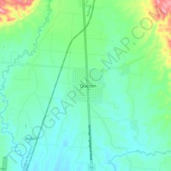
Name: Quezon topographic map, elevation, terrain.
Location: Quezon, Isabela, Cagayan Valley, 3324, Philippines (17.27194 121.56539 17.35194 121.64539)
Average elevation: 113 m
Minimum elevation: 78 m
Maximum elevation: 229 m
Make a donation
Gear up for your next adventure:
As an Amazon Associate, this site earns from qualifying purchases at no extra cost to you.
Other topographic maps
Click on a map to view its topography, its elevation and its terrain.