Geolocate

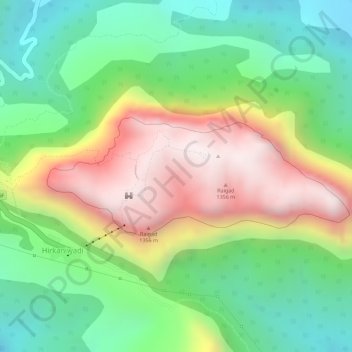
Raigad Fort topographic map

Click on the map to display elevation.

Raigad Fort

Located at an elevation of 820 metres (2,700 ft)above sea level in the Sahyadri mountain range, the fort offers panoramic views of the surrounding region. The fort was home to around 1,550 residents, with an average family size of five. Access to the fort requires ascending approximately 1,737 steps. Alternatively, visitors can use the Raigad Ropeway, an aerial tramway spanning 750 m (2,460 ft) in length and reaching a height of 400 m (1,300 ft), which transports passengers to the fort in approximately four minutes.

Wikipedia (CC-BY-SA 3.0)

About this map

Name: Raigad Fort topographic map, elevation, terrain.

Location: Raigad Fort, Lingana to Raigad, Vagheri, Chatri Nizampur, Vagheri, Mahad Taluka, Raigad, Maharashtra, 402305, India (18.23072 73.43435 18.24092 73.45876)

Average elevation: 448 m

Minimum elevation: 119 m

Maximum elevation: 866 m

Gear up for your next adventure:

🧦Merino Wool Hiking Socks - Moisture-wicking socks to prevent blisters during long topographic surveys
📷Backpack Camera Clips - Quick access to your camera while keeping your hands free for climbing
🌿Flora and Fauna Field Guides - Identify the plants and animals you encounter on your route
🔥Windproof Plasma Lighters - USB rechargeable lighters that work in high-altitude winds
🎒Ultralight Backpacks - Lightweight packs for long hikes

As an Amazon Associate, this site earns from qualifying purchases at no extra cost to you.