
Make a donation
Gear up for your next adventure:
As an Amazon Associate, this site earns from qualifying purchases at no extra cost to you.
Leonding topographic map
Click on the map to display elevation.
Make a donation
Gear up for your next adventure:
As an Amazon Associate, this site earns from qualifying purchases at no extra cost to you.
About this map
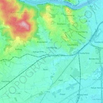
Name: Leonding topographic map, elevation, terrain.
Location: Leonding, Bezirk Linz-Land, Upper Austria, 4060, Austria (48.24367 14.20462 48.30982 14.28137)
Average elevation: 307 m
Minimum elevation: 251 m
Maximum elevation: 517 m
Make a donation
Gear up for your next adventure:
As an Amazon Associate, this site earns from qualifying purchases at no extra cost to you.
Other topographic maps
Click on a map to view its topography, its elevation and its terrain.
Make a donation
Gear up for your next adventure:
As an Amazon Associate, this site earns from qualifying purchases at no extra cost to you.
Enzenwinkl
Austria > Upper Austria > Bezirk Linz-Land > Leonding > Enzenwinkl
Average elevation: 330 m