Geolocate

Marion County topographic map

Click on the map to display elevation.

About this map

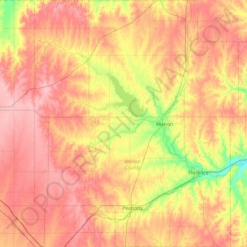
Name: Marion County topographic map, elevation, terrain.

Location: Marion County, Kansas, United States (38.08573 -97.37193 38.60956 -96.81951)

Average elevation: 439 m

Minimum elevation: 379 m

Maximum elevation: 488 m

Other topographic maps

Click on a map to view its topography, its elevation and its terrain.

Dalbey

United States > Kansas > Atchison County

Average elevation: 258 m

Harding Dam

United States > Kansas > Johnson County > De Soto

Average elevation: 252 m

Cottonwood

United States > Kansas > Jefferson County

Average elevation: 294 m

Riverton

United States > Kansas > Cherokee County > Riverton

Average elevation: 254 m

Prospect

United States > Kansas > Butler County

Average elevation: 417 m

Gear up for your next adventure:

Altimeter Watches - Watches with altitude tracking
👣Snake & Scrub Gaiters - Protection against spinifex, mud, and snakes while walking off-track
👕UPF 50+ Sun Shirts - Essential protection against the harsh Australian sun during field work
💡Collapsible Camping Lanterns - Illuminate your base camp or tent for map studying at night
🎒Hiking Backpacks - Backpacks designed for hiking and trekking

As an Amazon Associate, this site earns from qualifying purchases at no extra cost to you.