
Make a donation
Gear up for your next adventure:
As an Amazon Associate, this site earns from qualifying purchases at no extra cost to you.
Point of View topographic map
Click on the map to display elevation.
Make a donation
Gear up for your next adventure:
As an Amazon Associate, this site earns from qualifying purchases at no extra cost to you.
About this map
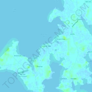
Name: Point of View topographic map, elevation, terrain.
Location: Point of View, Dorchester County, Maryland, United States (38.56040 -76.29328 38.60040 -76.25328)
Average elevation: 1 m
Minimum elevation: -2 m
Maximum elevation: 11 m
Make a donation
Gear up for your next adventure:
As an Amazon Associate, this site earns from qualifying purchases at no extra cost to you.
Other topographic maps
Click on a map to view its topography, its elevation and its terrain.
Upper Hooper Island
United States > Maryland > Dorchester County > Fishing Creek
Average elevation: 0 m
Taylor's Island Wildlife Management Area
United States > Maryland > Dorchester County
Average elevation: 1 m
Make a donation
Gear up for your next adventure:
As an Amazon Associate, this site earns from qualifying purchases at no extra cost to you.
Make a donation
Gear up for your next adventure:
As an Amazon Associate, this site earns from qualifying purchases at no extra cost to you.