
Make a donation
Gear up for your next adventure:
As an Amazon Associate, this site earns from qualifying purchases at no extra cost to you.
Fenton topographic map
Click on the map to display elevation.
Make a donation
Gear up for your next adventure:
As an Amazon Associate, this site earns from qualifying purchases at no extra cost to you.
Fenton
The topography of the Fenton area is predominantly rolling hills.
Make a donation
Gear up for your next adventure:
As an Amazon Associate, this site earns from qualifying purchases at no extra cost to you.
About this map
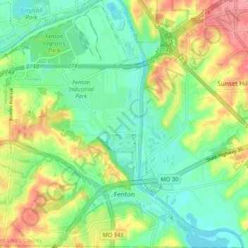
Name: Fenton topographic map, elevation, terrain.
Location: Fenton, Saint Louis County, Missouri, United States (38.50085 -90.47677 38.55822 -90.40498)
Average elevation: 149 m
Minimum elevation: 114 m
Maximum elevation: 206 m
Make a donation
Gear up for your next adventure:
As an Amazon Associate, this site earns from qualifying purchases at no extra cost to you.
Other topographic maps
Click on a map to view its topography, its elevation and its terrain.
Make a donation
Gear up for your next adventure:
As an Amazon Associate, this site earns from qualifying purchases at no extra cost to you.
Make a donation
Gear up for your next adventure:
As an Amazon Associate, this site earns from qualifying purchases at no extra cost to you.
Town and Country
United States > Missouri > Saint Louis County > Town and Country > Town and Country
Average elevation: 178 m
University City
United States > Missouri > Saint Louis County > University City > University City
Average elevation: 170 m
Make a donation
Gear up for your next adventure:
As an Amazon Associate, this site earns from qualifying purchases at no extra cost to you.
Clarkson Valley
United States > Missouri > Saint Louis County > Clarkson Valley
Average elevation: 195 m