
La Picherotte topographic map
Interactive map
Click on the map to display elevation.
About this map
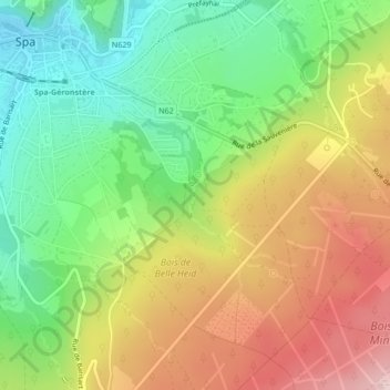
Name: La Picherotte topographic map, elevation, terrain.
Location: La Picherotte, Spa, Verviers, Liège, Wallonie, 4900, Belgique (50.47665 5.87691 50.48611 5.88623)
Average elevation: 374 m
Minimum elevation: 248 m
Maximum elevation: 529 m
Other topographic maps
Click on a map to view its topography, its elevation and its terrain.
Domaine de Bérinzenne
Domaine de Bérinzenne, Coupe-feu du Tir, Spa, Verviers, Liège, Wallonie, 4900, Belgique
Average elevation: 515 m
Lac de Warfaaz
Belgique > Wallonie > Spa > Jalhay
Lac de Warfaaz, Route du Lac de Warfa, Jalhay, Liège, Wallonie, 4845, Belgique
Average elevation: 336 m