
Amport topographic map
Interactive map
Click on the map to display elevation.
About this map
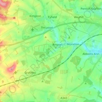
Name: Amport topographic map, elevation, terrain.
Location: Amport, Test Valley, Hampshire, England, United Kingdom (51.16207 -1.67238 51.22366 -1.55082)
Average elevation: 95 m
Minimum elevation: 56 m
Maximum elevation: 176 m
Other topographic maps
Click on a map to view its topography, its elevation and its terrain.
West Tytherley
United Kingdom > England > Hampshire > Test Valley
West Tytherley, Test Valley, Hampshire, England, United Kingdom
Average elevation: 73 m
North Baddesley
United Kingdom > England > Hampshire > Test Valley > North Baddesley
North Baddesley, Test Valley, Hampshire, England, United Kingdom
Average elevation: 42 m
Bossington
United Kingdom > England > Hampshire > Test Valley
Bossington, Test Valley, Hampshire, England, United Kingdom
Average elevation: 46 m
Andover
United Kingdom > England > Hampshire > Test Valley > Andover
Andover, Test Valley, Hampshire, England, United Kingdom
Average elevation: 90 m
Thruxton
United Kingdom > England > Hampshire > Test Valley
Thruxton, Test Valley, Hampshire, England, United Kingdom
Average elevation: 111 m
Islands
United Kingdom > England > Hampshire > Test Valley > West Tytherley
Islands, West Tytherley, Test Valley, Hampshire, South East England, England, United Kingdom
Average elevation: 65 m
Sherfield English
United Kingdom > England > Hampshire > Test Valley > Sherfield English
Sherfield English, Test Valley, Hampshire, South East England, England, United Kingdom
Average elevation: 59 m