
Rjazan topographic map
Interactive map
Click on the map to display elevation.
About this map
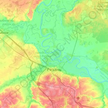
Name: Rjazan topographic map, elevation, terrain.
Location: Rjazan, Рязанская область, Centraal Federaal District, Rusland (54.52826 39.53667 54.81201 39.89958)
Average elevation: 118 m
Minimum elevation: 86 m
Maximum elevation: 185 m
Other topographic maps
Click on a map to view its topography, its elevation and its terrain.
Rjazan
Rusland > Рязанская область > Rjazan
Rjazan, Рязанская область, Centraal Federaal District, Rusland
Average elevation: 118 m