
Make a donation
Gear up for your next adventure:
As an Amazon Associate, this site earns from qualifying purchases at no extra cost to you.
The Cedars topographic map
Click on the map to display elevation.
Make a donation
Gear up for your next adventure:
As an Amazon Associate, this site earns from qualifying purchases at no extra cost to you.
About this map
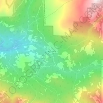
Name: The Cedars topographic map, elevation, terrain.
Location: The Cedars, Placer County, California, United States (39.23296 -120.37326 39.27296 -120.33326)
Average elevation: 1,904 m
Minimum elevation: 1,628 m
Maximum elevation: 2,329 m
Make a donation
Gear up for your next adventure:
As an Amazon Associate, this site earns from qualifying purchases at no extra cost to you.
Other topographic maps
Click on a map to view its topography, its elevation and its terrain.
Make a donation
Gear up for your next adventure:
As an Amazon Associate, this site earns from qualifying purchases at no extra cost to you.
Make a donation
Gear up for your next adventure:
As an Amazon Associate, this site earns from qualifying purchases at no extra cost to you.
North Tahoe Regional Park
United States > California > Placer County > Tahoe Vista
Average elevation: 2,007 m