
Town of Amherst topographic map
Interactive map
Click on the map to display elevation.
About this map
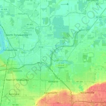
Name: Town of Amherst topographic map, elevation, terrain.
Location: Town of Amherst, Erie County, New York, United States (42.94584 -78.83250 43.08708 -78.69684)
Average elevation: 184 m
Minimum elevation: 169 m
Maximum elevation: 220 m
Other topographic maps
Click on a map to view its topography, its elevation and its terrain.
South Wales
United States > New York > Erie County
South Wales, Town of Wales, Erie County, New York, 14139, United States
Average elevation: 361 m
Sandy Beach
United States > New York > Erie County > Town of Grand Island
Sandy Beach, Town of Grand Island, Erie County, New York, 14304, United States
Average elevation: 175 m
Albany & School Triangle
United States > New York > Erie County > Buffalo
Albany & School Triangle, Buffalo, Erie County, New York, United States
Average elevation: 188 m
Town of West Seneca
United States > New York > Erie County
Town of West Seneca, Erie County, New York, 14224, United States
Average elevation: 200 m
Village of Orchard Park
United States > New York > Erie County > Town of Orchard Park
Village of Orchard Park, Town of Orchard Park, Aurora, Erie County, New York, 14127, United States
Average elevation: 262 m
Newstead
United States > New York > Erie County
Newstead, Erie County, New York, 14001, United States
Average elevation: 222 m
Town of Newstead
United States > New York > Erie County
Town of Newstead, Erie County, New York, 14001, United States
Average elevation: 213 m