
Tschoibalsan topographic map
Interactive map
Click on the map to display elevation.
About this map
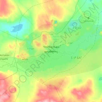
Name: Tschoibalsan topographic map, elevation, terrain.
Location: Tschoibalsan, Kherlen, Dornod, Mongolei (47.98124 114.41179 48.13378 114.74212)
Average elevation: 764 m
Minimum elevation: 714 m
Maximum elevation: 862 m
Tschoibalsan (mongolisch Чойбалсан) ist die Hauptstadt des Dornod-Aimag in der Mongolei und die viertgrößte Stadt des Landes. Bis 1941 trug die Stadt den Namen Bajan Tumen (Баян Тумэн), dann wurde sie zu Ehren des kommunistischen Führers Chorloogiin Tschoibalsan umbenannt. Sie liegt am Fluss Cherlen auf einer Höhe von 747 m ü M.